Edel Land including Steep Point
Steep Point is the most westerly point on mainland Australia. The Dutch seafarer William de Vlamingh named ‘Steyle Hock’ (Steep Point) in 1697 when anchored off the cliffs near the southern tip of Dirk Hartog Island.
Steep Point lies within the Edel National Park (reserve created in 2024) which extends to just south of False Entrance and encompasses much of Belefin Prong. Limestone cliffs rising 200 metres above the Indian Ocean on the western side of Edel Peninsula are backed by sweeping white sand dunes and secluded beaches on the eastern side.
Facilities in this remote area are limited to pit toilets at the Steep Point and Shelter Bay camping areas. You will need to bring in all you need and take your rubbish out with you. Remember to make sure you have sufficient fresh water, food and fuel.
Pets are not allowed at Steep Point and Edel Land. Campfires are not permitted.
Please read the visitor guide 2017 Edel Land and your permit conditions before you go.
Note: For those travelling through to Dirk Hartog Island National Park, contact the Steep Point Ranger to book your pre-barge campsite. For all other campsite bookings – see the camping below.
Access & Safety
Steep Point can only be accessed by high clearance four-wheel drive vehicle or by boat.
It is about 185km by road from the Northwest Coastal Highway to Steep Point, including 140km of unsealed road. The last 30km is a soft single-lane track winding around sand dunes. It is essential to lower tyre pressures to 20psi or less to avoid becoming bogged in this remote area. The drive to Steep Point from Denham takes about three to four hours.
The journey to Shelter Bay from Denham by boat via South Passage is about 50km.
This area is remote and has some inherent dangers including variable weather conditions — especially in summer when the park is hot, dry and windy — and a hazardous coastline with large surf, 200 metre high cliffs, blowholes and potentially dangerous marine animals in surrounding waters. For your safety:
- Notify a reliable person of your trip plans so that you can be traced in an emergency.
- Be prepared for the heat. Take at least 10 litres of water for each person per day.
- Exercise extreme caution near cliff edges especially when fishing.
- Supervise children at all times.


NOTE: For those travelling through to Dirk Hartog Island National Park, see contacts to call or email the Steep Point Ranger and book your pre-barge campsite.
To book a campsite, visit the Park Stay website.
Advance bookings are required and sites are very popular so booking well in advance is recommended.
Camping is available at Shelter Bay, The Oven and False Entrance. Most camp sites are at Shelter Bay which offers the best shelter from the prevailing southerly winds. The Oven is located on the Steep Point cliffs and is popular with people fishing from the cliffs, but is exposed and rocky. False Entrance is located on the south-western side of the park and has no facilities.

Arguably some of the best land based fishing in Australia occurs at Steep Point. Mackerel, trevally and even sailfish are caught off Steep Point’s cliffs, especially during summer. However this fishing requires special equipment to float baits offshore and to haul fish up the cliffs.
Boat-based fishing is also popular in this area with many people launching boats from Shelter Bay. The South Passage has strong currents and tidal movements and can be treacherous. Take all necessary precautions and ensure you have all the required safety equipment.
Fishing from the steep cliffs along Shark Bay’s western edge is dangerous and not all of the people swept from the cliffs have been seen again. Make sure you know what you’re doing and take the necessary precautions to stay safe.
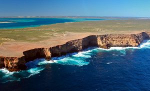
Zuytdorp Cliffs south of Steep Point
Zuytdorp Cliffs
The Zuytdorp Cliffs form an almost unbroken 200 kilometre arc between Steep Point and Kalbarri. They rise up to 200 metres out of the Indian Ocean and were named after the Zuytdorp, a Dutch ship wrecked on the cliffs in 1712.
From Steep Point you can follow the cliffs along the most westerly edge of Edel Land for more than 20 kilometres.
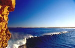
Waves rolling onto False Entrance beach
South Passage & Shelter Bay
Leeward of the Zuytdorp cliffs are crescent shaped beaches and relatively sheltered campsites from where small boats can be launched for fishing and diving.
May to October is the most popular time but the area’s popularity can make it difficult to get a campsite so book early.
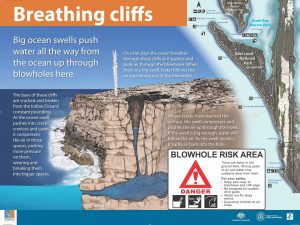
Blowhole explanation on sign at Thunder Bay
Blowholes
The cliffs come to life when massive waves crash against them, in places pushing up to the surface via blowholes. You can visit blowholes at False Entrance and just north of Thunder Bay.
False Entrance
False Entrance was so named because early mariners thought it was the entrance to Shark Bay between Dirk Hartog Island and Steep Point. Anglers fish from the exposed point for mackerel and other pelagic species in much the same way as at Steep Point.
Steep Point Ranger
PMB Useless Loop WA 6537
Ph: 08 9948 3993
Fax: 08 9948 3963
Email: steeppointranger@dbca.wa.gov.au
Radio channels: UHF 16, 27 Meg 68, VHF 16