About
On the edge of the Australian continent where the far west coast meets the sea is the Shark Bay World Heritage Area. Covering an area of more than 2.2 million hectares between 24 and 27 degrees south of the equator, it is one of the world’s greatest wilderness treasures.
This westernmost part of Australia has a unique combination of wildlife, flora and stunning scenery unlike that found anywhere else. Shark Bay is actually two bays sheltered by peninsulas and a long island. The local Malgana Aboriginal people know it as Gutharraguda, meaning ‘two waters’.
Although physically larger than some European nations, Shark Bay has a permanent population of fewer than 1,000 people. There are two main population centres – the town of Denham with a population of about 600, and the closed salt mining town of Useless Loop.
Most people earn their livelihood from industries that rely on the natural environment – tourism, fishing, pastoralism, and conservation management. Shark Bay’s inclusion on the World Heritage List in 1991 is due to its natural values and ensures recognition of obligations to care for them.
Find out more about the people of Shark Bay through the Shire of Shark Bay.
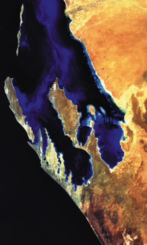
The shoreline of Shark Bay has a ‘W’ shape formed by the Edel Land peninsula and Dirk Hartog Island to the west, Peron Peninsula in the centre, and the eastern coastal strip.
Edel Land is typified by rocky limestone and long, white sand dunes. The western edge of this peninsula features dramatic cliffs dropping into the Indian Ocean while the eastern side has shallow sandy bays peppered with small rocky islands.
To the west and north are elongated limestone islands overlain with sand dunes – Dirk Hartog, Dorre and Bernier islands.
In the centre of Shark Bay, Peron Peninsula has rolling red sand hills and plains interspersed with salty gypsum hollows known locally as birridas. The coastal strip extending north to Carnarvon features tidal flats and an adjacent low-lying plain.
Marine environments cover about 70% of the Shark Bay World Heritage Area. The average depth of the clear sheltered waters is only nine metres and they are beautifully patterned with seagrass meadows, channels and banks.
The ‘W’ shape makes for coastline meandering more than 1,500km. It includes tidal flats, mangrove communities and white shell beaches in the shelter of the bay, and rocky reefs and cliffs on the deep seaward sides.
The peninsulas, prongs, islands and bays of Shark Bay are habitat for a range of plants and animals found in the wild nowhere else. Shark Bay also features the world’s most abundant marine stromatolites, living fossils representing the oldest forms of life on Earth.
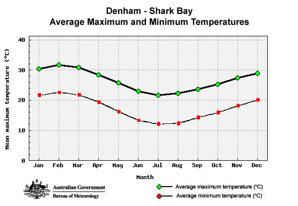
Shark Bay has a semi-arid climate with hot, dry summers and mild winters. The average annual temperature is 26.5ºC and the average annual rainfall is 228 mm. This mild climate is paired with a sometimes intense southerly wind, especially between October and April.
July is the coolest month with an average minimum of about 10ºC and maximum temperatures up to 20–25ºC. February is usually the hottest month with an average minimum of 23ºC and the maximum averaging 35ºC, although temperatures can exceed 40ºC.
July has the highest average rainfall of 56mm, while December is the driest month with rainfall averaging 1.3mm. December and January are the windiest months with average wind speeds exceeding 27 km/h. Cyclone season is from November to the end of April, although cyclones are not frequent.


