Land & Seascapes
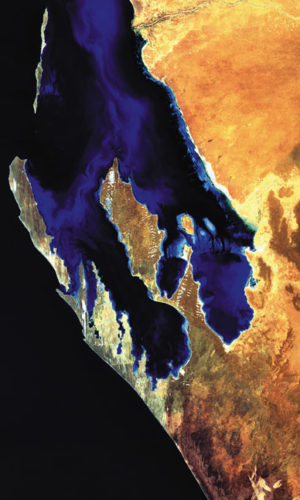
The shoreline of Shark Bay has a ‘W’ shape formed by the Edel Land peninsula and Dirk Hartog Island to the west, Peron Peninsula in the centre, and the eastern coastal strip.
Edel Land is typified by rocky limestone and long, white sand dunes. The western edge of this peninsula features dramatic cliffs dropping into the Indian Ocean while the eastern side has shallow sandy bays peppered with small rocky islands.
To the west and north are elongated limestone islands overlain with sand dunes – Dirk Hartog, Dorre and Bernier islands.
In the centre of Shark Bay, Peron Peninsula has rolling red sand hills and plains interspersed with salty gypsum hollows known locally as birridas. The coastal strip extending north to Carnarvon features tidal flats and an adjacent low-lying plain.
Marine environments cover about 70% of the Shark Bay World Heritage Area. The average depth of the clear sheltered waters is only nine metres and they are beautifully patterned with seagrass meadows, channels and banks.
The ‘W’ shape makes for coastline meandering more than 1,500km. It includes tidal flats, mangrove communities and white shell beaches in the shelter of the bay, and rocky reefs and cliffs on the deep seaward sides.
The peninsulas, prongs, islands and bays of Shark Bay are habitat for a range of plants and animals found in the wild nowhere else. Shark Bay also features the world’s most abundant marine stromatolites, living fossils representing the oldest forms of life on Earth.

